
New ECF cycle infrastructure factsheet: longitudinal gradients
02 Nov, 2023
ECF releases a new factsheet which compiles, compares and analyses requirements for longitudinal slopes across national and regional standards and guidelines from 12 countries.
The European Cyclists’ Federation (ECF) has published a new state-of-the-art factsheet on longitudinal gradients on cycling infrastructure. The report is a meta-analysis of requirements and recommendations from 12 different European countries with a diverse range of climates, levels of cycle use, population densities and topographies. Its recommendations contribute to the ongoing discussions at the United Nations Economic Commission for Europe level on quality requirements for cycle infrastructure.
Why are gradients important?
Longitudinal slopes affect cycling in two ways. Uphill cycling requires additional effort, which might be discouraging or prohibitive for some users (less fit, elderly, carrying children or significant luggage, on heavy cycles etc). Downhill cycling might seem easier, but with steep gradients, it can be a safety hazard, due to higher speeds and much longer braking distance (in addition to higher speeds, gravity is counteracting the braking power). Overall, elevation changes increase the energy expense of cyclists, therefore reducing the comfort of use and competitiveness of the cycle route.
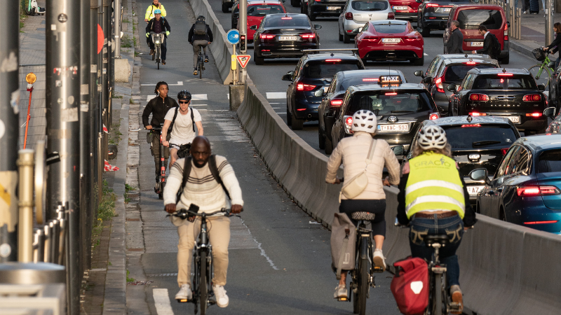
With 1.9 million cycles counted in 2022, Rue de la Loi is the most popular cycle route in Brussels. It funnels most of the cycle traffic between the centre and the European Quarter because the street crosses the valley of Maelbeek on a viaduct, minimising elevation change on the way. Photo credit: Goran Lepen.
How to quantify this aspect of the quality of cycle routes?
The key parameter for slopes is the longitudinal gradient, usually expressed as a percentage. A gradient of 5% means that you climb 5m on a ramp 100m long.
In France, Ireland and Poland, the maximum gradient for cycle infrastructure is set regardless of slope length or level difference. In practice, the same is applied in Finland and Norway in urban areas.
In other countries, the maximum acceptable gradient depends on the height difference to overcome (or the length of the slope). A short steep slope might be acceptable, especially if there is a straight flat section at the bottom of the slope that allows one to pick up speed before climbing and reduce it safely in the downhill direction. A longer climb or descent requires a gentler slope to be able to sustain the effort or manage speed.
To capture this dependency, Flanders and the Netherlands use a metric called slope severity. For a fixed slope severity threshold, the maximum gradient is inversely proportional to the height difference to overcome. Austria, Catalonia, Germany and Slovakia have an in-between approach, with maximum gradient depending on slope length or height difference, but the dependency is weaker than in the case of slope severity.
Recommendations
Cycle routes should be planned in a way that minimises elevation changes. Slopes should be gentle enough to make it easy to:
- cycle uphill without excessive effort,
- stop in the downhill direction whenever the situation requires it.
Following the meta-analysis of guidelines and standards from 12 countries, ECF formulated recommendations that vary the maximum longitudinal gradient depending on the category of the cycle route and the height difference to overcome. On a basic cycle route, up to 2m of height difference, a gradient of 10% is acceptable. For a main cycle route climbing 5m, 5% should not be exceeded and for a cycle highway overcoming more than 100 m of elevation change, a gradient of around 2% should be adopted to make the sustained effort feasible for different groups of users.

Recommended maximum gradient values for different categories of cycle routes in the function of the height difference to overcome.
Additionally, on slopes with a gradient exceeding 3%:
- Infrastructure width should be increased.
- A design speed of at least 40 km/h should be assumed and all the related geometric parameters, i.e. curve radii and sight distances, should be increased accordingly.
- Timings of traffic signals should be increased for cyclists travelling in the uphill direction.
Moreover:
- No sharp curves, obstacles or crossings without priority should be located in the middle or at the bottom of the slope; a section of flat, straight cycle track is necessary to safely reduce the speed after descending the slope.
- Level sections can be used in-between inclines to provide an opportunity to rest or reduce speed, especially if the height difference exceeds 5 m.
- There should be no sudden changes in gradient, which may cause “bumps” and crashes. The transition between flat sections and slopes, or between slopes with different gradients, should be designed with the use of vertical curves.
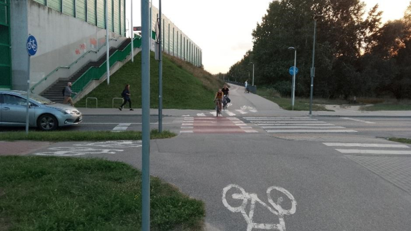
Świderska Street, Warsaw. The cycle ramp leading from a bridge ends on a crossing with a local road without good visibility splay and without clear priority established. Six car-cycle accidents have been registered on the crossing between 2014 and 2022.
Download the report
You can download the full report here.
Regions:
Topics:
Related content
QECIO 2.0: Unleashing the Power of OpenStreetMap for Sustainable Mobility
This year, ECF has once again explored the potential of using OpenStreetMap (OSM) to quantify cycling infrastructure across Europe. Our tool, Quantifying Europe’s Cycling Infrastructure using OpenStreetMap (QECIO) 2.0, equips policymakers and...
Andrea Chavez
28 Jul, 2023

UNECE to develop pro-cycling measures to double cycling levels by 2030 with ECF’s support
UNECE has convened a group of experts, including ECF, to help with the implementation of the infrastructure module of the Pan-European Master Plan for Cycling Promotion. We take a look at some of the key elements being discussed by this group.
Aleksander Buczynski
21 Jun, 2023
TEN-T and cycling: mapping good and bad practices across Europe
ECF highlights good and bad practices from across Europe of where the Trans-European Transport Network interacts with cycling.
Aleksander Buczynski
26 Jan, 2023
Contact the author

Recent news!

26 Nov, 2024


Upcoming events
Contact Us
Avenue des Arts, 7-8
Postal address: Rue de la Charité, 22
1210 Brussels, Belgium
Phone: +32 2 329 03 80
Email: office@ecf.com